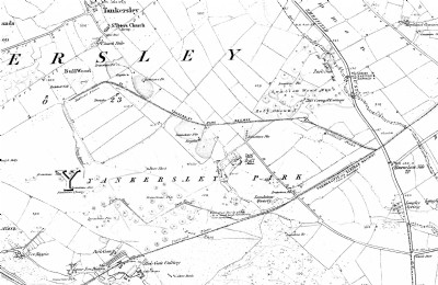
Tankersley Park Ironstone Pits Iron Mine (United Kingdom)
Extensive area of systematic ironstone working by bell pits around Tankersley Old Hall. A railway and a tramway were provided to remove the ore. The north-eastern section was named Swallow Wood Mine on the 1850 OS map (see extract in Archive Album) and was served by the Tankersley Park Railway which connected with the Thorncliffe and Elsecar Railway via an inclined plane. The southern section was served by a tramway also connecting to the Thorncliffe - Elsecar line. The pushpin is centred on the southern area which is now a golf course. The northern section (Swallow Wood) is across the M1 motorway in a wooded area.
Photos of Tankersley Park Ironstone Pits Iron Mine
Historic Photographs Of Tankersley Park Ironstone Pits
(1 photo)
Last updated August 15th 2013 by
skiprat

Photographs Of Tankersley Park Ironstone Pits
(0 photos)
Last updated August 15th 2013 by
skiprat
Google Earth Map of Tankersley Park Ironstone Pits Iron Mine
Other location/mapping information:
Latitude: 53.4835949755325
Longitude: -1.47099868895558
Landranger grid reference: SK351987
Easting: 435100
Northing: 398700