Silkstone Main (Stainborough) Colliery Coal Colliery (United Kingdom)
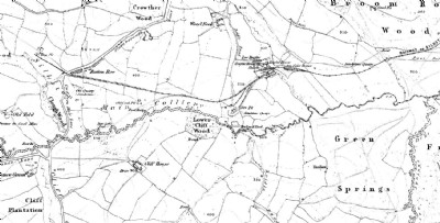
Shown on the 1850 OS map as a half mile string of pits from Top Pit Wood in the west then along the Crane Brook Dyke to a site with engines. The pits were linked by a tramway which went on north-east all the way to Worsbrough Basin on the Dearne & Dove Canal.
The mine was closed by the 1892 survey.
NB the name Silkstone Main has been used to describe other mines in the Silkstone/Silkstone Common area.
Photos of Silkstone Main (Stainborough) Colliery Coal Colliery
Historic Photographs Of Silkstone Main (Stainborough) Colliery
(1 photo)
Last updated August 12th 2013 by
skiprat

Photographs Of Silkstone Main (Stainborough) Colliery
(0 photos)
Last updated August 12th 2013 by
skiprat
Google Earth Map of Silkstone Main (Stainborough) Colliery Coal Colliery
Other location/mapping information:
Latitude: 53.5107842635559
Longitude: -1.52344370764947
Landranger grid reference: SE316017
Easting: 431600
Northing: 401700