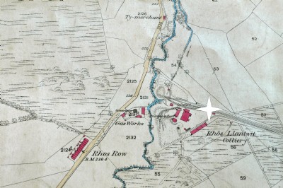
Rhos Llantwit Coal Colliery (United Kingdom)
Sunk in 1862 to No. 3 Llantwit (Mynyddislwyn) seam at 156 yds. A new shaft was added in 1871. Closed 1892.
Photos of Rhos Llantwit Coal Colliery
Historic Photographs Of Rhos Llantwit
(1 photo)
Last updated January 17th 2011 by
Lister
Google Earth Map of Rhos Llantwit Coal Colliery
Other location/mapping information:
Latitude: 51.5819
Longitude: -3.20793
Landranger grid reference: ST164877
Easting: 316400
Northing: 187700