Home > Mines, Quarries & Sites > Pontrhydygroes Lead Mill

Pontrhydygroes (Pont-Rhyd-Y-Groes) Lead Mill (United Kingdom)


Spirit of the Miners project.

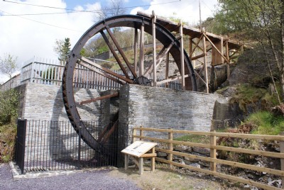
Photos of Pontrhydygroes Lead Mill

Photographs Of Pontrhydygroes
Photographs Of Pontrhydygroes (1 photo)
Last updated June 5th 2009 by markc
Historic Photographs Of Pontrhydygroes
Historic Photographs Of Pontrhydygroes (0 photos)
Last updated June 5th 2009 by markc

Google Earth Map of Pontrhydygroes Lead Mill


Other location/mapping information:

Latitude: 52.3333
Longitude: -3.85353
Landranger grid reference: SN738722
Easting: 273800
Northing: 272200

Documents for Pontrhydygroes Lead Mill

Sorry, there are no documents currently available. If you have any documents you can share please click the 'Upload a Document' tab.

See also:

Pontrhydygroes Lead Mill served all the following:

Glogfach Lead Mine

Pontrhydygroes Lead Mill was served by:

Level Fawr (Pontrhydygroes) Lead Tunnel

See more:

All lead mills in United Kingdom (SN)
All lead mills in United Kingdom