Pentrich And Oakerthorpe Coal Tramway (United Kingdom)
Pentrich and Oakerthorpe Tramway (Gangway)
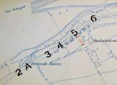
This tramway was opened in 1817 and ran from the Cromford Canal at Hartshay Hill to Pits around Pentrich (such as Waterloo Colliery), a distance of approx 1.25 miles to Broadoaks being recorded. A branch was added to Oakerthorpe (Longcroft) Colliery a further 1.25 miles away to the North.
A good deal of the route north beyond the road from Pentrich to Swanwick can be traced. On this section can be found a nice embankment made of colliery waste some 20ft high and just after a nice curved alignment following the edge of the woods. Passed Longcroft farm the route is ploughed under but maps point to it following a hedge line north down to the site of Oakerthorpe (Longcroft) Colliery. It had to cross a 20ft deep narrow valley which it appears to have done on another earth embankment built above a brick lined Culvert to direct the stream. 2 possible boundary posts sit in the woods close by. To the east of this location lie the remains of a small brick works inc kiln in the woods.
It is assumed to have been a gangway of the Outram type but that cannot be given as a definate and in recent walks no stone blocks could be found built into walls etc as with other gangways.
Grid given is for the centre section of traceable route towards Longcroft.
The southern Hartshay end of the route (at the Cromford) canal was destroyed/buried by the A610 upgrade SK388515, the far end is at SK397548.
I have put on a google map illustrating the route at
[url]http://maps.google.co.uk/maps/ms?hl=en&gl=uk&ie=UTF8&oe=UTF8&msa=0&msid=106730726527184400737.00044dff013e6359bcf21[/url]
Photos of Pentrich And Oakerthorpe Coal Tramway
Historic Photographs Of Pentrich And Oakerthorpe
(3 photos)
Last updated January 30th 2009 by
shovel_6

Photographs Of Pentrich And Oakerthorpe
(0 photos)
Last updated May 25th 2008 by
ICLOK
Google Earth Map of Pentrich And Oakerthorpe Coal Tramway
Other location/mapping information:
Latitude: 53.0773
Longitude: -1.41183
Landranger grid reference: SK395535
Easting: 439500
Northing: 353500