Park Burn Shaft Fluorite Mine (United Kingdom)
Shaft at west end of open cut, adjacent to Park Burn
Photos of Park Burn Shaft Fluorite Mine

Photographs Of Park Burn Shaft
(0 photos)
Last updated August 27th 2014 by
james l
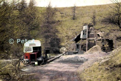
Historic Photographs Of Park Burn Shaft
(2 photos)
Last updated August 22nd 2014 by
Yorkshireman
Google Earth Map of Park Burn Shaft Fluorite Mine
Other location/mapping information:
Latitude: 54.7444131877081
Longitude: -2.12489962575574
Landranger grid reference: NY919388
Easting: 391900
Northing: 538800