Oakenshaw Colliery (Brancepeth 'B' Pit) Coal Mine (United Kingdom)
Information, history photographs (current and archive) and documents for Oakenshaw Colliery Coal Mine.
Photos of Oakenshaw Colliery Coal Mine
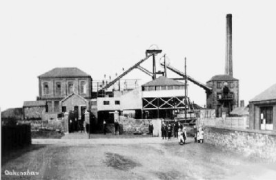
Historic Photographs Of Oakenshaw Colliery
(1 photo)
Last updated December 9th 2010 by
rodel

Photographs Of Oakenshaw Colliery
(0 photos)
Last updated December 9th 2010 by
rodel
Google Earth Map of Oakenshaw Colliery Coal Mine
Other location/mapping information:
Latitude: 54.7321
Longitude: -1.6925
Landranger grid reference: NZ199375
Easting: 419900
Northing: 537500