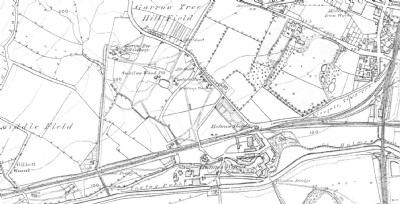
Garrow Tree Hill Colliery Coal Colliery (United Kingdom)
Site was between Kimberworth and Masbrough and adjacent to Swallow Wood Pit. Shown on OS maps of the 1850s but gone by 1892. There appears to have been a tramway to the canal 600m to the south.
Photos of Garrow Tree Hill Colliery Coal Colliery
Historic Photographs Of Garrow Tree Hill Colliery
(1 photo)
Last updated August 2nd 2013 by
skiprat

Photographs Of Garrow Tree Hill Colliery
(0 photos)
Last updated August 2nd 2013 by
skiprat
Google Earth Map of Garrow Tree Hill Colliery Coal Colliery
Other location/mapping information:
Latitude: 53.4301564697841
Longitude: -1.38736839923452
Landranger grid reference: SK407928
Easting: 440700
Northing: 392800