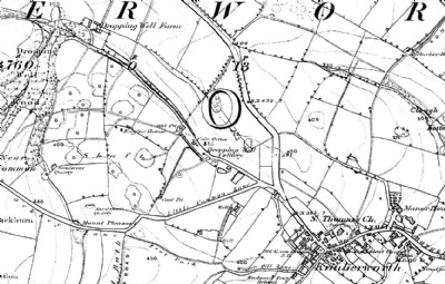
Dropping Well Colliery Coal Colliery (United Kingdom)
Small colliery with coke ovens to the north-west of Kimberworth village. The 1850s OS map (see extract in Archive Album) shows an area of bell pits to the west of the colliery.
Photos of Dropping Well Colliery Coal Colliery

Photographs Of Dropping Well Colliery
(0 photos)
Last updated July 17th 2014 by
pwhole
Historic Photographs Of Dropping Well Colliery
(1 photo)
Last updated August 16th 2013 by
skiprat
Google Earth Map of Dropping Well Colliery Coal Colliery
Other location/mapping information:
Latitude: 53.4356186205138
Longitude: -1.40083886117141
Landranger grid reference: SK398934
Easting: 439800
Northing: 393400