Church Gresley Coal Colliery (United Kingdom)
Information, history photographs (current and archive) and documents for Church Gresley Coal Colliery.
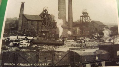
Photos of Church Gresley Coal Colliery
Historic Photographs Of Church Gresley
(1 photo)
Last updated March 15th 2016 by
Lister

Photographs Of Church Gresley
(0 photos)
Last updated June 29th 2013 by
LeeW
Google Earth Map of Church Gresley Coal Colliery
Other location/mapping information:
Latitude: 52.759413004269
Longitude: -1.56852778745058
Landranger grid reference: SK291181
Easting: 429100
Northing: 318100