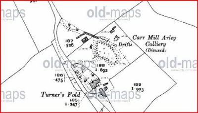
Carr Mill Arley Coal Colliery (United Kingdom)
Lime vale road .
Managed by the platts.
Not shown on 1909 map, shown as disused on 1928 map where it referes to a drift.
Photos of Carr Mill Arley Coal Colliery
Historic Photographs Of Carr Mill Arley
(1 photo)
Last updated December 20th 2010 by
Lister

Photographs Of Carr Mill Arley
(0 photos)
Last updated December 20th 2010 by
Lister
Google Earth Map of Carr Mill Arley Coal Colliery
Other location/mapping information:
Latitude: 53.4873
Longitude: -2.71884
Landranger grid reference: SJ524992
Easting: 352400
Northing: 399200